
In early September, SIOS (Svalbard Integrated Arctic Earth Observing System) will offer a training course on how to effectively use remote sensing data acquired from satellites, from the air or from the ground, and their associated tools and software in the context of terrestrial research in Svalbard.
The course is intended for field scientists, Ph.D. students and technicians with no or little experience with remote sensing techniques.
The training will be delivered by remote sensing experts from SIOS member institutions, international teachers and potential virtual talks from ESA experts.
· Time: 31 August – 4 September 2020* (starting Monday morning, ending Friday at lunch time, depending on flights)
· Location: Longyearbyen, Svalbard
· Application deadline: 7 May
Confirmed teachers (will be updated)
· Hans Tømmervik, NINA
· Roberto Salzano, CNR
· Lars Eklundh, Lund University
· Luc Girod, University of Oslo
· Richard Hann, UNIS/NTNU
· Agnar Sivertsen, NORCE
Note: Due to the COVID-19 pandemic, the dates are not set in stone. If the pandemic is still a risk factor, the course will be delayed towards the end of September, postponed to 2021 or offered as a remote class instead of in-person.
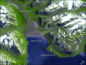
*Image captured by Advanced Spaceborne Thermal Emission and Reflection Radiometer (ASTER) on NASA’s Terra satellite on July 12, 2003. NASA image courtesy GSFC/METI/ERSDAC/JAROS, and the U.S./Japan ASTER Science Team.